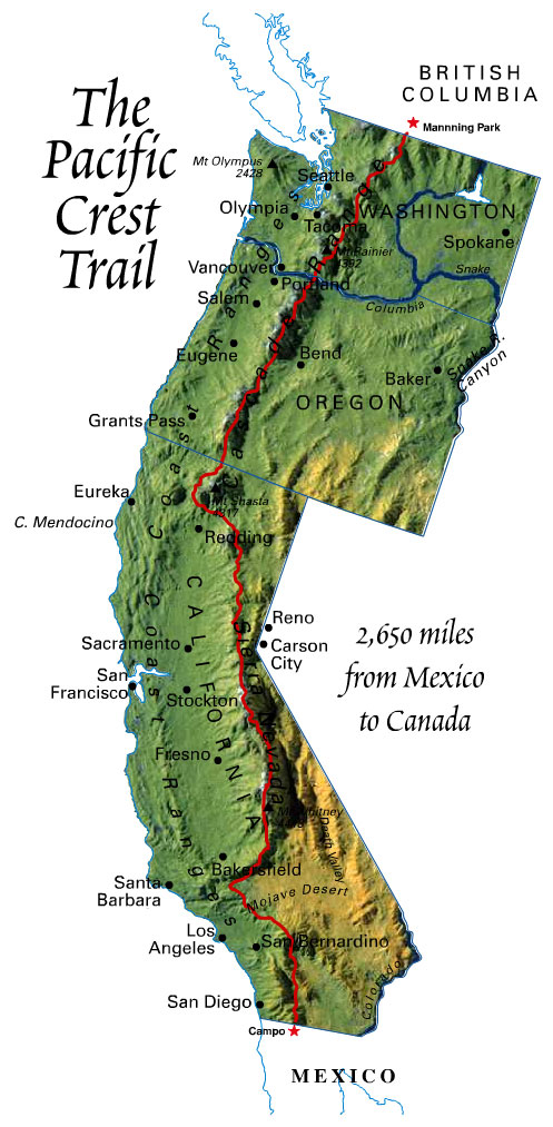
Every year, a few hundred people attempt to hike the entire trail (thru-hike) in one journey. I'll be one of them in 2013! The trail passes through myriad landscapes; beginning in the deserts and mountains of Southern California, continuing through the Sierras, moving on to the majestic Trinity Alps in Northern California, and lastly traversing the Cascades in Oregon and Washington. This journey usually takes about 5-6 months.
Beginning in Campo, California, hikers traverse the San Jacintos and a small part of the Mojave desert, and shortly thereafter enter the mighty Sierra Nevada mountain range. Many take the opportunity to summit the tallest mountain in the contiguous United States, Mt. Whitney, as the trail passes by. Next, the trail nears Mammoth Lakes, and then directly passes through Yosemite National Park's Tuolumne Meadows, and then moves north to Lake Tahoe. Leaving Tahoe, the trail heads north toward Mt. Shasta and enters Northern California's Trinity Alps. Entering Oregon near Ashland in the Cascades, the trail journeys past Crater Lake and then north past the Three Sisters, Mt. Hood, and into the Columbia River Gorge. The trail enters Washington at the Bridge of the Gods - at 140 feet, also the lowest elevation of the trip - and continues north through Washington until the end of the trail at Manning Park, Canada.
To learn more about the PCT, I recommend visiting the Pacific Crest Trail Association's website. Acting as stewards of the trail, the PCTA is committed to preserving and protecting the PCT.
No comments:
Post a Comment